Friday, August 28, 2015

Day 4 Mt Hood Hut to Hut Circumnavigation on the MTB

Erin concocted a stellar green chicken curry on Saturday night...amazing what some creativity can do with limited resources for food!  We once again went to bed with full bellies and woke up to the haze in the air.
The awesome dinner the night before was followed up with some banana pancakes for breakfast just to make sure we all left full!  Mission accomplished.  

Day 4 was our last day on the bikes...bittersweet...

The profile for the ride looked encouraging...it was mostly downhill back to Hood River and we certainly were not disappointed with the prospect of an easier day.  There were options to take a couple of detours.  One option was to tie into the Post Canyon trail system and the other was to go to Lost Lake.  We decided neither was all that appealing.  Post Canyon would probably be a zoo on Sunday (weekend) and most likely not super fun loaded down with a bunch of gear.  Lost Lake lost it allure considering the reason to do it was for views and there was still a thick smoky haze in the air.  

We took the path of least resistance and opted for the mellow ride back in.  We spent the day making our way back to Hood River via dirt roads and paved roads.  I did not even bother to take pictures as we headed back to the starting point. 

It was indeed a short day (about 2 1/2 hrs of ride time) and we made it back to the car without incident.  Once at the car we wanted to hit the Pfriem brewery for a post circumnavigation celebratory beer.  The celebration was we had a b-day in the house so it seemed like a great logical finishing place to toss a beer back and chillz before heading back home where life awaited us.


Wednesday, August 26, 2015

Day 3 Mt Hood Hut to Hut Circumnavigation on the MTB

Day 2 was behind us and it was time to pony up for day 3.  Day 3 was our longest mileage day and still had a punch of around 5K of climbing projected.

We woke up with a not so pleasant surprise on Saturday morning.  The plan was to get up early and get going soon thereafter in order to try to avoid the forecasted heat for the day.  We had a long day in the saddle and also had a long 2K foot climb towards the end of the day.

The surprise was as soon as we stepped outside, a thick smoke filled the air.  Until now, we had had beautiful clear skies with views for miles and miles.  This morning we woke up to thick smoke and could smell fire in the air.  We all felt pretty vulnerable in that we were tucked away deep in the woods and could not help but think there was a certain urgency to get out of dodge.  We speculated that there must have been a fire nearby as the stench in the air was thick with burning forest.

After a quick breakfast of instant oatmeal, Erin and I did not waste much time in getting moving.  The route took us up and over Barlow Pass where we continued to smell and see the smoke in the air. There was a breeze that was moving the trees and helping them shed their needles.  Erin had a slight moment of panic thinking it was ash until she realized what was going on.  The mind starts to jump to conclusions in these moments so I could empathize with the thought process!  The dirt road up Barlow Pass was chunky but fortunately not too steep.

We reached a clearing with a couple of campsites and felt a little surprised to see and hear people again.  The funny thing is that we say a Harley parked in one of the campsites and I thought to myself how that must not have been a fun ride in on the dirt roads we were riding through.

After a couple of weird head scratchers of managing the fire whereabouts concerns, we peaked Barlow Pass and crossed over the PCT where the dirt road T'd into a paved road.  The lighting was slightly weird...there was a red haze in the air that once again felt slightly apocalyptic.

We were relieved to be on a paved road thinking that we at least felt a little closer to civilization and safety relative to the unknown fire.

The route took us downhill on the paved road where we would pass the Women's Pioneer Grave.  We stopped for a brief moment and thought about how challenging that trek must have been many moons ago.  It was at the moment that I realized we were just on a pretty historic route that we had just climbed up.  I guess fear of fire will pretty much make a dude forget about a lot of stuff...

We carried on with out descent and eventually ended up hitting a major freeway for a couple miles to connect to Trillium lake.  This was another rude awakening as cars zoomed by us at highways speeds.  The mind quickly adjusted to civilization again as we took our turn to Trillium Lake.  We wound our way around the lake with campsites and people galore (or so it seemed given the recent solitude we had just recently treasured).  We did not even bother to stop at the viewpoint where Mt Hood looms at the end of the lake...it was smoked in and we could barely see the other side of the lake.  I took a picture anyways and we kept plodding along.

The GPS file for this day was also a little shaky...it did not pick up the route until an hour into the ride and some of the directions and lack of signs on roads made for some interesting navigational trial and error.  The intent was to catch single track trail from Trillium and ride it into the town Rhododendron.  We took the right at the fork where that option was supposed to unveil itself...after a quick descent we reached an opening where we saw several signs that said Private Property, No Trespassing, etc...There was no sign of a trailhead anywhere so we deduced we took a wrong turn...we climbed back up and retraced our steps...back to descending on the dirt road.

I referenced a fold out map of local trails that we took with us and we noticed we were originally in the right place to connect to the trail but unfortunately the signage and lack of better detail on our directions led us astray...After studying the map a little longer, we saw we could hook into  another trail (Still Creek) and connect that to the original trail we had missed.  Unfortunately we missed several miles of downhill single track but again made a mental note to remember the opportunity for the future.

The Still Creek trail was a very very pleasant surprise.  It started off with a few punches to the gut...a steepish (with all our gear) climb that took us to the ridge line where we traversed and then dropped into the campground where we could connect to the 'ghost' trail we missed.  That section of trail was perhaps the best part of the day...it was prime!  Unfortunately, it was only about a mile of smiles until we dropped back into the campground.

We meandered through the campground looking for the connecting trailhead to our 'ghost' trail.  While riding through the campground we saw several fires blazing...Somehow it irked me to see the fires given there were strict no campfire signs everywhere you looked.  Apparently the camp host was turning a blind eye and apparently we were also a little sensitive given the panicky tone of the start of the day due to fire.

The trailhead was found and soon enough we were back on our merry way descending through some super mellow double-track that occasionally turned to single.  In a short spurt we were in the town of Rhododendron and once again saw cars and people galore.  We stopped at the local food store...precious purchases included a couple of adult beverages to be enjoyed later!  mmm mmm!
We were now approaching the queen climb of the day...ahead of us was a 2,000 ft climb up to Lolo Pass.  I figured it had to be better than some of the dirt climbs we had done prior.  My reasoning was that it was 2K over about 12 miles so the grade couldn't be too unreasonable...plus, we were on pavement!

The route took us up Road 18 where the 2 lane road did not have much of a shoulder to ride on.  Cars zoomed by us and we were happy to get off the main road after several miles.  We still had about 1,400 ft of climbing to do and I kept thinking the grade was very manageable!
After turning on to the alternate road up to Lolo Pass, we continued to go up up up...after a couple of turns, the grade kicked up and un-relented!  The road stayed steep with no let up for miles...I monitored my Garmin closely as I watched the ft tick away as we climbed.  I was out of my saddle doing the single speed side to side slow grind and it was kicking my ass!  In my mind, I had made a mental note that this climb was a 2K ft climb...after some groveling and continued butt whoopin', I hit that magic 2K mark and son of a bitch, the road continued to climb!  The extra 200 ft of 'bonus' climbing was enough to shatter my fragile state of mind at the time...Eventually, we made it to the top and it was time to connect to Lolo Pass.  I could not help but wonder about the judgement of buying and humping the 22oz brew up during the grunt of climb.

At this point we had about 2 miles left to the cabin and we knew the worst was over.  We turned onto a dirt road where we rapidly descent for a quick 1/2 mile...and then there it was...another friggin' climb!  We had to climb what we had just descended.  We found our next turn off and all I could think about was we had about a mile to go, and the hut would be in sight!  As we made our last turn, we stared up at some eroded steepness...I took about 5 pedal strokes, thought better of it and then dismounted and took my bike for a walk.  Shortly after, we got back on our bikes and Erin mentioned how they really seemed to make a person work for that last mile.  It was probably more a function of our fragile psyches at that moment but I fully concurred!

Alas, the hut came into view and we saw that we arrived as they were re-stocking.  We hung out for a little while and talked to our hero of the day who was re-stocking the hut with food.  We walked around to the backside of the hut and stared in the direction where Mt Hood should be...he pointed in the direction and all we could was haze.  This was supposed to be the best view of the trip!   It turned out to be a bit of a bust.

In short order, we rummaged through food and filled our bellies.  Erin had picked up some green curry mix while at the store earlier in the day and the idea was to make some green curry and rice later that evening.  As the day progressed, the skies seemed to clear just enough to see the outline of Mt Hood...a little while later, you could actually start to see features on the mountain.  It was far from clear but it let the imagination run wild in a smoke free world...

Our hut-mates rolled in and we reminisced about the climbs and suffering of the day...it was sort of a ritual at this point.  A couple of hours later we were inhaling our green chicken curry and all felt very satisfied.  We kept going in / out of the hut and checking to see if the views of Hood were getting any better...only slightly.

It was sort of neat to think that just a day prior, we were on the other side of Mt Hood with a totally different view of the majestic peak.

Day 3...in the bag baby!  It was a big day but we had the bulk of the difficult days behind us and day 4 was supposed to be the pay-off day with lots of descending!  Now that was a nice thought....


Tuesday, August 25, 2015

Day 2 Mt Hood Hut to Hut Circumnavigation on the MTB

After a full afternoon of refueling, we went to bed and tried to get some shut-eye.   We woke up and got the day rolling without too much haste.  I grazed on oatmeal as we started to think about the day ahead.

We decided to pick up part of the Surveryor's Ridge single track and link it into our route as the trail paralleled the road which was to be the start of our day.  The day started with a nice punchy climb and we quickly realized that the additional weight we were carrying on our bike and on our backs would impact the handling of our bikes on the trail.

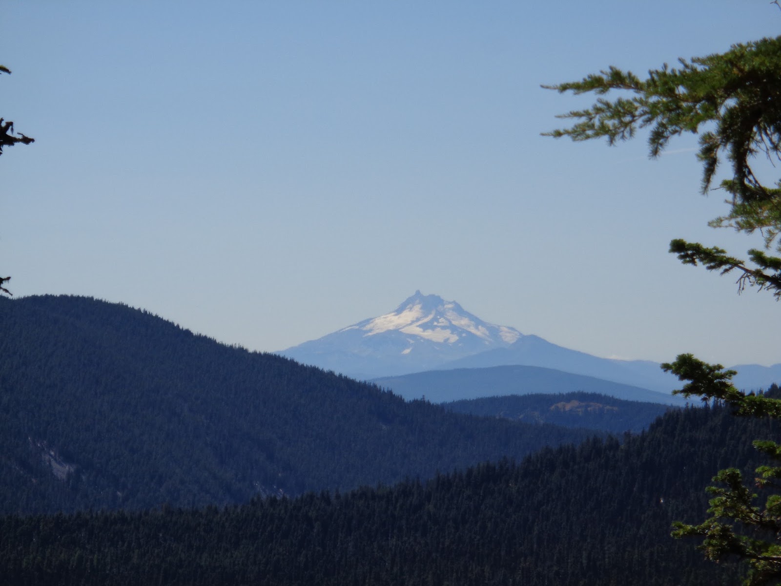
The mind wrapped itself around trying to adjust for the additional weight as we lumbered through the single track trail to phenomenal views of Mt Hood.  A couple of lookouts provided for great photo's of Hood.  We had been on this trail a couple of years prior so we sort of kind of knew what to expect and understood that despite being a little hampered by our touring setup, it was worth the effort for the views.

It was a really nice and peaceful way to start the day as we rolled along the ridge and enjoyed the trail.  I came to a junction with the road and stopped to wait for Erin.  After a couple of minutes I heard this loud crashing sound mixed in with trees and branches breaking.  My mind wondered what was going on as I did not remember a particularly tekkie section or even a drop off from the trail that would warrant the noise.  The mind deduced it must have been some sort of road we were unaware of that was the source of said commotion.  Not so much...I was starting to turn the bike around to go check on what was going on and about 10 seconds later I hear Erin's voice yelling my name.  I quickly started back on the trail and saw her coming in my direction.
She exclaimed ' I just saw a bear!!!'....It turns out we must have spooked the bear and it ran across the trail in front of her, barreling downhill running through trees until he found a tree he nimbly scampered up.  Erin looked fully awake now and was explaining that she was happy not to see any cubs and that the black bear was a pretty good size dude!

We both kept an ear for any additional noises as we referenced the map to try to figure out what direction to take on the road that would tie us back into our original intended route.  Soon enough, we were rolling downhill and Erin was talking out loud about how quickly her mind assessed the situation...'Bear!!, adult black bear, no cubs, fast and nimble!'

The bikes rolled along and the road started to curve around to a point where we questioned our direction.  We referenced the maps while at the next junction and figured out we had to retrace our steps back to where the trail crossed the road and head in the opposite direction to meet the route.  We climbed back up the road and tried enjoying the early morning temps.

In no time, we were back on route and spinning along.  On tap for the day was one big old climb...it was a 2,000 ft climb and it loomed like a dark cloud...we knew it was going to be a grunt and I was again wondering about the sanity of choosing to single speed this trip.  Too late now...the choice was made and it was time to put on the big boi pants : )

As we made our way to the start of the climb, we noticed a few trailheads and kept talking about how much more exploration was to be had up there.  We had done some rides up there but were just starting to realize how we had barely scratched the surface...mental note: must come back and explore sans tour set up!

The inevitability of the looming dark cloud finally met us face to face.  I took a gander at the GPS / elevation in order to monitor the climbing progress.  In a short while, we met up with the rest of our hut-mates and I mentioned how Erin had a good story to tell...Pretty soon, the grade got steeper....and unrelenting...and for extra added bonus fun, the road became brake bumpy and loose.  Steep grade + loose gravel + brake bumps + singlespeed = OUCH...yuppers...dumbass comes to mind...
The legs ached, the body argued, but the head prevailed...After what seemed like a long while, we peaked and took satisfaction in thinking that the climb we just did was probably about the worst we would encounter on this trip.

We were working our way south during the day and would eventually start heading in a westerly direction.  After taking a quick breather at the top of the hill, we started down an unmaintained road that made me think that I was super grateful not to be climbing up the steep and rocky road.  Within a short distance from starting, we saw a lookout with some amazing views of Mt Hood.  We stopped, marveled, took pix and then kept moving.  In the back of my mind I knew we were supposed to descend and then climb back out of the descent.  I kept hoping that the climb out would be more reasonable relative to the descent we were on.

Fortunately for us, the climb out was not as loose or steep but it was still a challenge to psych the mind up for climb.  We were getting close to a section that we could tie in some more single track that paralleled our route.  We opted against it because we had heard that the trail was very loose and sandy and not worth the effort.  Again, mental note made to come back and explore.

The route took us along the other side (east) of the ridge and we got to a great lookout that gave us some amazing views towards the east and south.  We easily spotted Mt Jefferson and could even see Sisters and BrokenTop from our viewpoint.  At the bottom of the ridge was a little lake that looked like a great place to chill...unfortunately it was probably about 1,000 ft below our elevation and there did not appear to be an easy way there.  We took the views in for a while and enjoyed the thought that the climbing was more or less behind us for the day.  Now, we got to descend for a while!

The weird thing about bikepacking (ultra light style considering we were not carrying food or sleeping bags, etc) is that you do all this climbing, but there is no single track trail descent as a reward.  Most of the times you get to descend chunky dirt roads - the reward is the process of getting from point A to point B and trying to take in the views when you get the chance.

The bikes rolled downhill and hit a paved road that continued to bring us to a lower elevation.  I held off the brakes and enjoyed the fast descents...the GPS tickled 40's and I tried to keep a long line of sight for cars.  The route took us to the bottom of the road where it turned back into dirt after crossing another paved road.  We pedaled along knowing that we only had about 7 miles left and they should be easy pedaling.

After a couple of quick turns, we started another steep descent and our Garmins started to chirp that we were off course.  After a quick confirmation that it was not the case, we continued downhill.  I guessed that our Garmin was losing contact with satellites because we were descending deeper into the woods.  In the back of my mind, I tried to ignore the possibility that we were actually off course and would have to retrace our steps.

At our next junction, we were assured that we were on track (YES, we actually had a working GPS file for day 2!!)...again, having the written directions and GPS was definitely the way to go!
At this point we knew we had 5 miles left alongside a river...I figured it should be easy spinning considering the grade should be mellow.  The grade was indeed mellow, however the road had a surprise in store for us.  The road was consistently this loose and sandy surface that made a guy work hard to pedal...urgggg...just a little added extra butt whoopin' to get to the hut.

We plugged along for what seemed like way too long until we saw our green hut.  Our home for the evening embraced us as we foraged through the food cabinets and inhaled some quick hit calories.

The allure to this hut (Barlow) was that it was near a creek so we would at least be able splash some water on us to get rid of the layers of dirt over 2 days.....ahhh, now it was time to relax and enjoy the fruit of our labor:  eating to replenish lost calories and to try the process of recovery.

We chilled and talked about what to do for dinner considering the random cans and boxes of food.  Each hut had each own character and this one had the pleasant surprise of snickers!!

Our hut mates rolled up and were equally disgusted with the last 5 miles of loose road...they quickly got over it (as did we) when they dove into the food cabinet.

Day two in the books...it was a long day with a little under 5K of climbing....time to relax and try to get a good night of sleep before embarking on the longest mileage of the trip on day 3.


Monday, August 24, 2015

Day 1 Mt Hood Hut to Hut Circumnavigation on the MTB

As an anniversary gift to ourselves, the missus signed us up for a hut to hut trip around Mt Hood via mountain bike.

The general outline was to go around Mt Hood via bike from hut to hut - duh!  Each day's ride ended up at a hut that was fully stocked with food, water, etc...The cabins are pretty rustic, but felt like home in no time.  No running water, no electricity, but plenty of food if you could find creative ways to cook with a random assortment of food goods.

The outfit that offers the self-guided tour was not very helpful beyond what literature they have on their site (which always leaves one wanting/needing more as questions arise).  A couple of Erin's emails went unanswered but we figured we 'probably' had enough info to get from point A to point B to point C to point D and then back to point A again.

They had sent us 4 GPS files for the 4 days so we figured we were in pretty good hands and that once the files were downloaded to our GPS units, we would be in great hands.  Fortunately, we had backup plans which included the written directions provided (which turned out to be a little book - something that is less than ideal when you have to carry everything you need for 4 days...and yes a small book does indeed impact the weight on your back, and more importantly, the weight on yo' tooshie).
We also decided to take along a couple of fold out maps that would collectively provide us the lay of the land.

We got up early on Thursday morning with the intent to drive from Bend to Hood River such that we could get riding between 9-10 a.m.  The drive up was relatively uneventful except for the apocalyptic haze from the fires around Warm Springs.  The further north we drove, the clearer it got and we felt relieved to see the skies were getting smoke free as we approached our destination of Hood River

As for directions and GPS, suffice it to say it was a good thing we had the written directions and the maps to references as the GPS files were not very dependable.  We turned on our Garmins and started the course for day 1, only to realize they had sent us the wrong files.  DOH!  This could have been a really big deal if we did not have the backups and the backup to the backup on directions.  The reason it could have been a big deal is there is a myriad of roads that have multiple turns in the backwoods where a wrong turn could easily put you in a bad spot with no water, etc.

OK, so we would have to ride by the written directions.  We used rough odometer readings to follow the turn by turn directions as we left Hood River.

As luck would have it, we bumped into the other group that was signed up for the hut to hut bike-a-thon as we were unloading.  After some quick intro's we hit the road and ended up riding together to the town of Mosier.  This section was pretty mellow and very scenic as we rolled along the Columbia through some old tunnels.  We know we had a big day of climbing ahead of us so we tried to enjoy the rollers while they lasted.  Initial beta from the Hut to Hut crew said it would be a full belly of climbing with around 6,100 ft of elevation gain.

Soon enough we were in Mosier and navigated our way through a couple turns until we hit Husky road where things were about to get ummm 'hilly'!
We made a right hand turn and looked at the mouthful of climbing ahead of us.  The grade pitched up and I immediately questioned the sanity of doing this hut to hut trip on the single speed (let alone on the ratio I had) while being loaded up with gear...hmmm, it was going to be a long 4 days of groveling...
After a little shock to the system, the body and mind got into the rhythm of climbing while being out of the saddle.
We followed a series of turns from the written directions and kept continuing to see great views of the surrounding mountains as we climbed.  The higher we got, the better the views got.  We had some nice views of Mt Hood, Adams, Rainier...pretty sweet indeed....it helped distract from the grind of climbing.

At some point we reached the hut up on Surveyor's ridge.  As the hut came into view, we both relaxed a little and had a slight sense of relief and accomplishment.  On paper, this was the biggest climbing day so we were happy to 'put it in the bank'.  It ended up being around 5,100 ft of climbing in just under 26 miles...pretty solid day...

 
The unexpected surprise was seeing a couple of bikes as we rolled up to the hut.  After removing helmets and gloves, the door opened and a couple of guys rolled out.  It turns out they were getting ready for their second day of adventuring and were in the process of getting ready to leave for day 2 of riding.  In the back of my mind, I was wondering whether they were cutting it a little close on time but figured they knew what lay ahead.  After a few pleasantries, they ended up leaving about 30 minutes later and we had the hut to ourselves.

We quickly rummaged through the food and gobbled down some instant gratification as we settled in and got the lay of the land.

There was a short hike from the hut to a little scenic viewpoint (with a picnic table!) with a kick ass view of Mt Hood.  We were happy to be there and took it all in.
A little later, the rest of the group of three ladies showed up and they too went through the process of getting settled in...we compared stories for the day and soon enough it was time to go watch the sun set from the viewpoint.

not a bad way to finish up....

some pix of the day's ride: